* These totals are subject to errors and ommisions.
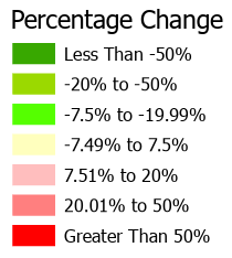
Formula: 1-(Previous Value / Current Value)
* These totals are subject to errors and ommisions.
* These totals are subject to errors and ommisions.
Tax Types (Use ctrl-click to turn all checkboxes on/off.)

Tax Line Descriptions (Use ctrl-click to turn all checkboxes on/off.)

Tax Line Descriptions (Use ctrl-click to turn all checkboxes on/off.)
The tax line data information in this application is for tax cycle Oct 2025 - Oct 2026.
Historical records are for tax years 2013-2025.
This data is subject to errors and ommissions. Please check legal records before making any assumptions.
Select Single Property:
Click on the map to retrive property information records most recent tax values.
Select Multiple Properties:
Click the drawing tool icon above (the pencil). Once the tool is active (green) draw a free-hand shape on the map to select parcels that it intersects - total tax amounts will be calculated. Pan functionality will be suspended until the draw tool is deactivated (red) by clicking the icon again.
Select Individual Tax Lines/Types:
Select the 'Tax Types' tab above then select various tax types and/or tax line descriptions. Depending on which tax types are checked, you will see the corresponding tax lines appear in the Tax Line Descriptions selection dialog. You can select as many or as few items as desired. Once your choices are made, you can either create a new selection (with the draw tool active) on the map, or, if there is a current selection, click the re-query button next to the draw tool.
Moving Around
To move the map press and hold the left mouse button on top of the map to drag it in the desired direction. You can zoom in or out using your mouse center scroll wheel, or alternatively using the zoom in/zoom out buttons in the lower left corner of the map. Double-clicking the left mouse button will zoom into the map one step.
Search
Click the search button in the upper right corner of the map to search for an address or parcel.
Additional Layers
You can change the layers shown in the map by opening the 'Layers' dialog. From here you can toggle the various layers such as Roads, Address Points and City/County boundaries. You can also bookmark your location in the 'Bookmarks' tab.